Merrimac, Florida Weather
Issued: 5:55 pm EDT Apr 18, 2024 Latitude: 28.7252731 Longitude: -81.5622952 View on Google Maps
|
|
|
|
|
|
|
|
|
|
 |
 |
 |
 |
 |
|
 |
|
| Low: °F |
High: °F |
High: °F |
High: °F |
High: °F |
High: °F |
High: °F |
High: °F |
| Low: °F |
Low: °F |
Low: °F |
Low: °F |
Low: °F |
Low: °F |
|
| Mostly Clear |
Sunny |
Morning Fog |
Mostly Sunny |
Thunderstorms |
Sunny |
Rain |
Rain |
Current Conditions at
LEESBURG - (KLEE)
84°
Clear
as of 4:53 PM EDST
Rel. Humidity: 45%
Dew Point: 61°F
Visibility: 10 Miles
Pressure: 30.04 in.
Flight Rule: VFR
Cloud Level(s): Clear
Current Conditions at
ORLANDO HERN APRT - (KORL)
88°
Mostly Cloudy
as of 4:53 PM EDST
Rel. Humidity: 40%
Dew Point: 61°F
Visibility: 10 Miles
Pressure: 30.03 in.
Flight Rule: VFR
Cloud Level(s): Broken at 6500ft
Current Conditions at
SANFORD - (KSFB)
88°
Clear
as of 4:53 PM EDST
Rel. Humidity: 33%
Dew Point: 55°F
Visibility: 10 Miles
Pressure: 30.02 in.
Flight Rule: VFR
Cloud Level(s): Clear
Current Conditions at
ORLANDO INTL - (KMCO)
88°
Partly Cloudy
as of 4:53 PM EDST
Rel. Humidity: 40%
Dew Point: 61°F
Visibility: 10 Miles
Pressure: 30.03 in.
Flight Rule: VFR
Cloud Level(s): Few at 4500ft, Scattered at 30000ft
|
Tonight... Mostly clear, with a low around 66. East wind around 5 mph becoming calm in the evening. |
|
|
Friday... Sunny, with a high near 91. Calm wind becoming west around 5 mph in the morning. |
|
 |
Friday Night... Patchy fog after 5am. Otherwise, mostly clear, with a low around 63. West wind 5 to 10 mph. |
|
|
Saturday... Patchy fog before 10am. Otherwise, sunny, with a high near 92. West wind 5 to 10 mph. |
|
|
Saturday Night... Mostly clear, with a low around 65. West wind 5 to 10 mph. |
|
|
Sunday... Mostly sunny, with a high near 91. West southwest wind 5 to 15 mph, with gusts as high as 20 mph. |
|
 |
Sunday Night... A 20 percent chance of showers and thunderstorms. Partly cloudy, with a low around 67. West wind 10 to 15 mph, with gusts as high as 20 mph. |
|
|
Monday... A 40 percent chance of showers and thunderstorms. Mostly sunny, with a high near 86. West wind 10 to 15 mph, with gusts as high as 20 mph. |
|
 |
Monday Night... Partly cloudy, with a low around 64. Northwest wind 10 to 15 mph becoming north northeast after midnight. |
|
|
Tuesday... Sunny, with a high near 87. North northeast wind around 10 mph. |
|
|
Tuesday Night... Mostly clear, with a low around 63. East wind around 10 mph. |
|
|
Wednesday... A 20 percent chance of showers. Sunny, with a high near 88. East northeast wind 5 to 10 mph becoming northwest in the afternoon. |
|
|
Wednesday Night... Mostly clear, with a low around 65. East wind 5 to 10 mph becoming south southeast after midnight. |
|
|
Thursday... A 20 percent chance of showers. Sunny, with a high near 88. East wind 5 to 10 mph. |
|
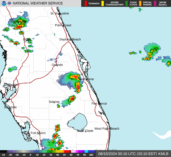
Current Radar Image
Sun Almanac for Merrimac, Florida
Sunrise: 06:57 AM
Sunset: 7:54 PM
Civil Sunrise:06:32 AM
Civil Sunset: 8:19 PM
Nautical Sunrise: 06:03 AM
Nautical Sunset: 8:47 PM
Astro Sunrise: 05:34 AM
Astro Sunset: 9:17 PM
Florida's Current Temperatures
 Florida's Satellite Image
 Florida's Current Wind Direction
| National Summary |
of upper and lower values of current conditions amongst 6527 locations
in the contiguous United States |
|
High
Temp |
97° |
Terrel County Arpt, Texas
and 2 other locations
|
|
Low
Temp |
19° |
Perryton, Texas
|
|
Wind
Speed |
54mph |
Salida Mountain, Colorado
|
|
Wind
Gust |
63mph |
Salida Mountain, Colorado
|
|
Wind
Chill |
3° |
Perryton, Texas
|
|
Heat
Index |
103° |
Faith Ranch A/P, Texas
and 1 other location
|
|
High
Pressure |
30.79Hg |
Ottawa, Ohio
|
|
Low
Pressure |
29.74Hg |
Washington, Missouri
|
|
| # Locations Reporting Snow |
10 |
|
| # Locations Reporting Rain |
101 |
|
| # Locations Reporting Thunderstorms / Lightning |
5 |
|
| # Locations Reporting Fog |
2 |
|
| Average Temperature in the Contiguous USA |
66° |
|
Any use of the information on this page is at your own risk. This information should not be relied upon in life-threatening situations, potential financial loss situations or in lieu of any officially disseminated information. Visit the
National Weather Service for official information.