No Watches or Warnings for Holland
Issued: 4:40 pm PDT Apr 24, 2024 Latitude: 42.1276157 Longitude: -123.5389529 View on Google Maps
|
|
|
|
|
|
|
|
|
|
 |
 |
 |
 |
 |
 |
 |
|
| Low: °F |
High: °F |
High: °F |
High: °F |
High: °F |
High: °F |
High: °F |
High: °F |
| Low: °F |
Low: °F |
Low: °F |
Low: °F |
Low: °F |
Low: °F |
|
| Cloudy |
Rain |
Rain & Snow |
Rain & Snow |
Rain |
Rain & Snow |
Mostly Sunny |
Rain & Snow |
Current Conditions at
BROOKINGS ARPT - (KBOK)
50°
Partly Cloudy
as of 8:56 PM PDST
Rel. Humidity: 93%
Dew Point: 48°F
Visibility: 10 Miles
Pressure: 30.11 in.
Flight Rule: VFR
Cloud Level(s): Scattered at 800ft
Current Conditions at
CRESCENT CITY - (KCEC)
52°
Cloudy
as of 8:56 PM PDST
Rel. Humidity: 87%
Dew Point: 48°F
Visibility: 10 Miles
Pressure: 30.14 in.
Flight Rule: IFR
Cloud Level(s): Solid Overcast at 700ft
|
Tonight... Partly cloudy, with a low around 41. Calm wind. |
|
|
Thursday... Rain. High near 54. Light and variable wind becoming southwest 6 to 11 mph in the afternoon. Chance of precipitation is 90%. New precipitation amounts of less than a tenth of an inch possible. |
|
 |
Thursday Night... Rain. Low around 42. Southwest wind 7 to 10 mph. Chance of precipitation is 100%. New precipitation amounts between a tenth and quarter of an inch possible. |
|
|
Friday... Rain. Snow level 4700 feet. High near 52. West southwest wind around 7 mph. Chance of precipitation is 90%. New precipitation amounts between a tenth and quarter of an inch possible. |
|
 |
Friday Night... A 30 percent chance of rain before 11pm. Snow level 4700 feet lowering to 4100 feet after midnight . Mostly cloudy, with a low around 37. Southwest wind 3 to 8 mph. |
|
|
Saturday... A 20 percent chance of rain after 11am. Snow level 4000 feet rising to 5500 feet in the afternoon. Mostly cloudy, with a high near 58. |
|
 |
Saturday Night... A 30 percent chance of rain before 11pm. Mostly cloudy, with a low around 41. |
|
|
Sunday... A slight chance of rain. Partly sunny, with a high near 62. |
|
 |
Sunday Night... A chance of rain. Mostly cloudy, with a low around 39. |
|
|
Monday... A slight chance of rain before 11am. Snow level 4600 feet. Partly sunny, with a high near 60. |
|
|
Monday Night... Partly cloudy, with a low around 34. |
|
|
Tuesday... Mostly sunny, with a high near 64. |
|
|
Tuesday Night... A slight chance of rain. Snow level 5200 feet lowering to 4000 feet after midnight . Partly cloudy, with a low around 37. |
|
|
Wednesday... A chance of rain. Snow level 3800 feet rising to 4800 feet in the afternoon. Partly sunny, with a high near 62. |
|
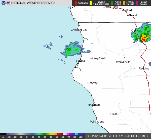
Current Radar Image
Sun Almanac for Holland, Oregon
Sunrise: 06:17 AM
Sunset: 8:07 PM
Civil Sunrise:05:47 AM
Civil Sunset: 8:37 PM
Nautical Sunrise: 05:10 AM
Nautical Sunset: 9:14 PM
Astro Sunrise: 04:31 AM
Astro Sunset: 9:53 PM
Oregon's Current Temperatures
 Oregon's Satellite Image
 Oregon's Current Wind Direction
| National Summary |
of upper and lower values of current conditions amongst 6868 locations
in the contiguous United States |
|
High
Temp |
86° |
Presidio, Texas
|
|
Low
Temp |
-20° |
Front Royal, Virginia
|
|
Wind
Speed |
28mph |
Pagosa Springs, Colorado
|
|
Wind
Gust |
44mph |
Greenville, Maine
|
|
Wind
Chill |
2° |
Frenchville, Maine
|
|
High
Pressure |
30.38Hg |
Salida Mountain, Colorado
|
|
Low
Pressure |
29.68Hg |
Malta, Montana
|
|
| # Locations Reporting Snow |
2 |
|
| # Locations Reporting Rain |
16 |
|
| # Locations Reporting Fog |
5 |
|
| Average Temperature in the Contiguous USA |
55° |
|
Any use of the information on this page is at your own risk. This information should not be relied upon in life-threatening situations, potential financial loss situations or in lieu of any officially disseminated information. Visit the
National Weather Service for official information.