Buttermilk, Kansas Weather
No Watches or Warnings for Buttermilk
Issued: 11:15 am CDT Apr 24, 2024 Latitude: 37.1028045 Longitude: -99.3253907 View on Google Maps
|
|
|
|
|
|
|
|
|
|
 |
 |
 |
 |
 |
|
|
|
| High: °F |
Low: °F |
High: °F |
High: °F |
High: °F |
High: °F |
High: °F |
High: °F |
| Low: °F |
Low: °F |
Low: °F |
Low: °F |
Low: °F |
|
| Thunderstorms |
Thunderstorms |
Thunderstorms |
Sunny |
Thunderstorms |
Sunny |
Sunny |
Sunny |
Current Conditions at
ALVA REGIONAL AIRPT - (KAVK)
66°
Mostly Clear
as of 12:15 PM CDST
Rel. Humidity: 37%
Dew Point: 39°F
Visibility: 10 Miles
Pressure: 30.18 in.
Flight Rule: VFR
Wind Data
16 MPH
120° Southeast
Cloud Level(s): Few at 11000ft
Current Conditions at
MEDICINE LAKE - (KP28)
64°
Partly Cloudy
as of 11:56 AM CDST
Rel. Humidity: 34%
Dew Point: 36°F
Pressure: 30.19 in.
Current Conditions at
WEST WOODWARD - (KWWR)
59°
Cloudy
as of 12:10 PM CDST
Rel. Humidity: 51%
Dew Point: 41°F
Visibility: 10 Miles
Pressure: 30.21 in.
Flight Rule: VFR
Cloud Level(s): Solid Overcast at 6000ft
Current Conditions at
PRATT - (KPTT)
64°
Clear
as of 12:10 PM CDST
Rel. Humidity: 29%
Dew Point: 32°F
Visibility: 10 Miles
Pressure: 30.21 in.
Flight Rule: VFR
Wind Data
14 MPH
140° Southeast
Cloud Level(s): Clear
|
This Afternoon... A 20 percent chance of showers and thunderstorms. Mostly cloudy, with a high near 68. East southeast wind around 14 mph. |
|
|
Tonight... A 40 percent chance of showers and thunderstorms, mainly after 9pm. Cloudy, with a low around 52. East southeast wind 10 to 14 mph. |
|
|
Thursday... A chance of showers and thunderstorms, then showers likely and possibly a thunderstorm after 1pm. Mostly cloudy, with a high near 79. Breezy, with a south southeast wind 11 to 21 mph. Chance of precipitation is 60%. New rainfall amounts between a quarter and half of an inch possible. |
|
 |
Thursday Night... Showers and thunderstorms likely before 10pm, then showers likely and possibly a thunderstorm between 10pm and 1am, then a slight chance of showers and thunderstorms after 1am. Mostly cloudy, then gradually becoming mostly clear, with a low around 55. Windy, with a south southeast wind 20 to 25 mph, with gusts as high as 39 mph. Chance of precipitation is 60%. New rainfall amounts between a quarter and half of an inch possible. |
|
|
Friday... Sunny, with a high near 84. Breezy, with a southwest wind 18 to 21 mph. |
|
 |
Friday Night... Mostly clear, with a low around 53. |
|
|
Saturday... A 40 percent chance of showers and thunderstorms after 1pm. Sunny, with a high near 85. Windy. |
|
|
Saturday Night... A 40 percent chance of showers and thunderstorms, mainly before 1am. Partly cloudy, with a low around 52. Windy. |
|
|
Sunday... Sunny, with a high near 75. |
|
|
Sunday Night... Mostly clear, with a low around 45. |
|
|
Monday... Sunny, with a high near 78. |
|
 |
Monday Night... Clear, with a low around 51. |
|
|
Tuesday... Sunny, with a high near 87. |
|
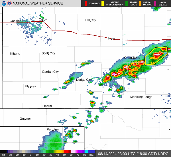
Current Radar Image
Sun Almanac for Buttermilk, Kansas
Sunrise: 06:50 AM
Sunset: 8:21 PM
Civil Sunrise:06:23 AM
Civil Sunset: 8:48 PM
Nautical Sunrise: 05:50 AM
Nautical Sunset: 9:21 PM
Astro Sunrise: 05:15 AM
Astro Sunset: 9:56 PM
Kansas' Current Temperatures
 Kansas' Satellite Image
 Kansas' Current Wind Direction
| National Summary |
of upper and lower values of current conditions amongst 7146 locations
in the contiguous United States |
|
High
Temp |
88° |
Mcallen, Texas
|
|
Low
Temp |
-31° |
Front Royal, Virginia
|
|
Wind
Speed |
31mph |
Sidney, Nebraska
|
|
Wind
Gust |
44mph |
Pine Ridge, South Dakota
and 2 other locations
|
|
Wind
Chill |
7° |
Perryton, Texas
|
|
Heat
Index |
94° |
Mcallen, Texas
|
|
High
Pressure |
30.47Hg |
Salida Mountain, Colorado
|
|
Low
Pressure |
29.66Hg |
Clayton Lake, Maine
|
|
| # Locations Reporting Snow |
3 |
|
| # Locations Reporting Rain |
46 |
|
| Average Temperature in the Contiguous USA |
63° |
|
Any use of the information on this page is at your own risk. This information should not be relied upon in life-threatening situations, potential financial loss situations or in lieu of any officially disseminated information. Visit the
National Weather Service for official information.