Winds & Temperatures Aloft Help
Before you use this data there are some things that you should know.
Hour of Forecast
The hour of forecast is in reference to the time when the forecast was made. It is possible to receive a forecast based upon a time period that has already passed. For example, if the forecast was made 9 hours ago and you are checking the 6 hour forecast, you will receive a report that expired 3 hours ago. Please check the valid times for the correct times to use the forecasts.
Valid Times
The forecast times are local times of the city selected based upon the am pm clock. If you live on the west coast and select a city in the Eastern Time Zone, the forecasted time will be for the Eastern Time Zone and not the Pacific Time Zone. If the forecast has a valid time from 1000 pm to 300 am on the 5th day of the month, you must take into consideration that the 1000 pm portion occurs on the previous day.
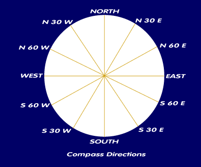
Wind Directions
The wind direction forecasts is based upon compass bearings or azimuth directions.For compass directions, the four main headings are NE, SE, SW, and NW and are based upon True North.
Above each compass direction is a graphic which illustrates the direction the wind is forecasted to blow towards. You should look at this as if North is pointing towards the top of your computer screen.
If your launch site's facing is based upon a compass reading, you must adjust the directions on these pages by your local natural magnetic declinations. In some parts of the country the natural magnetic delication can be as much as 20 degrees while other parts are only a few degrees. If you wish to find out what your local magnetic declination is, look at your local USGS Quadrangle map. Somewhere on these USGS sheets there is a magnetic declination. The declination may be expressed in a difference or variance from true north.
You can also click here for a Map of Magnetic Declinations in the USA
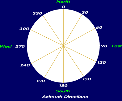
For azimuth directions, the heading are based upon a 360 degree circle where 0 is north, 90 is east, 180 is south, and 270 is west.
A wind direction of 350 Azimuth means the wind is coming from azimuth 350 (N 10 W) and going towards azimuth 170 (S 10 E). This script shows which way the wind is coming from as shown by the numbers below the arrows. The arrows are shown in the direction the wind is going towards.
Wind Speed
Wind speeds are in the standard USA Imperial system of Miles per Hour.
Temperature
The temperatures shown are measured in the standard USA Imperial system of Fahrenheit. A (-) before a number shows that the temperature is below zero. Wind chills are calculated using the new 2000 temperature conversion factor as recommended by the National Weather Service.
Vertical Datum
All elevations are based upon Mean Sea Level and not AGL.
Forecast Summary
The forecasts summary gives all of the data in a tabular format for easy comparision.
Raw Data
The raw data is the basis of the graphs and charts shown on the page. The information was fetched from the latest forecasts at the National Oceanic and Atmospheric Administration. Click on the link to review the raw data.
Risk and Liability
This forecasted data should be considered accurate but as with all weather forecast things tend to change from when the forecast was made. We cannot be held liable for the raw data obtained from the National Weather Service. By using these forecast, you agree to accept all risks associated with use of this forecast.
Script Enhancement
If you have any suggestions as to how we can improve the script to assist you in your flying or to suggest another script, please email us.